


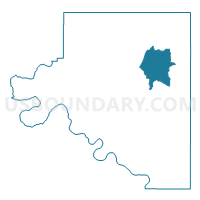
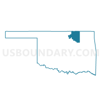
Voting District 102, Osage County, Oklahoma
About
Outline

Summary
| Unique Area Identifier | 654910 |
| Name | Voting District 102 |
| County | Osage County |
| State | Oklahoma |
| Area (square miles) | 89.58 |
| Land Area (square miles) | 89.14 |
| Water Area (square miles) | 0.44 |
| % of Land Area | 99.51 |
| % of Water Area | 0.49 |
| Latitude of the Internal Point | 36.74881230 |
| Longtitude of the Internal Point | -96.19619270 |
Maps

Graphs
Select a template below for downloading or customizing gragh for Voting District 102, Osage County, Oklahoma


Neighbors
Neighoring Voting District (by Name) Neighboring Voting District on the Map
- Voting District 101, Osage County, OK
- Voting District 107, Osage County, OK
- Voting District 108, Osage County, OK
- Voting District 109, Osage County, OK
- Voting District 110, Osage County, OK
- Voting District 114, Osage County, OK
Top 10 Neighboring County Subdivision (by Population) Neighboring County Subdivision on the Map
Top 10 Neighboring Elementary School District (by Population) Neighboring Elementary School District on the Map
Top 10 Neighboring Unified School District (by Population) Neighboring Unified School District on the Map
- Bartlesville Public Schools, OK (38,264)
- Pawhuska Public Schools, OK (5,022)
- Barnsdall Public Schools, OK (2,489)